


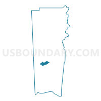
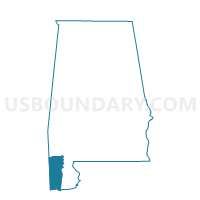
St. Elmo Seventh Day Adventist, Mobile County, Alabama
About
Outline

Summary
| Unique Area Identifier | 522619 |
| Name | St. Elmo Seventh Day Adventist |
| County | Mobile County |
| State | Alabama |
| Area (square miles) | 11.14 |
| Land Area (square miles) | 11.13 |
| Water Area (square miles) | 0.01 |
| % of Land Area | 99.88 |
| % of Water Area | 0.12 |
| Latitude of the Internal Point | 30.51786090 |
| Longtitude of the Internal Point | -88.25789550 |
Maps

Graphs
Select a template below for downloading or customizing gragh for St. Elmo Seventh Day Adventist, Mobile County, Alabama


Neighbors
Neighoring Voting District (by Name) Neighboring Voting District on the Map
- Callahan Boys and Girls Club, Mobile County, AL
- First Baptist Church of Irvington, Mobile County, AL
- Friendship Baptist Church, Mobile County, AL
- Grand Bay Middle School, Mobile County, AL
- Meadowlake Elementary, Mobile County, AL
- Mt. Ararat Baptist Church, Mobile County, AL
- Union Baptist Church, Mobile County, AL
Top 10 Neighboring County Subdivision (by Population) Neighboring County Subdivision on the Map
Top 10 Neighboring Place (by Population) Neighboring Place on the Map
Top 10 Neighboring Unified School District (by Population) Neighboring Unified School District on the Map
Top 10 Neighboring State Legislative District Lower Chamber (by Population) Neighboring State Legislative District Lower Chamber on the Map
Top 10 Neighboring State Legislative District Upper Chamber (by Population) Neighboring State Legislative District Upper Chamber on the Map
Top 10 Neighboring 111th Congressional District (by Population) Neighboring 111th Congressional District on the Map
Top 10 Neighboring Census Tract (by Population) Neighboring Census Tract on the Map
- Census Tract 65.02, Mobile County, AL (11,958)
- Census Tract 66, Mobile County, AL (5,548)
- Census Tract 65.01, Mobile County, AL (4,878)
- Census Tract 71.01, Mobile County, AL (4,717)
- Census Tract 67.02, Mobile County, AL (4,064)
- Census Tract 71.02, Mobile County, AL (3,110)